Created by: Mario Arnone 20384799; Jamie Banks 20381429; Louis-Pierre Bélec 20369401; Maya Levinshtein 20374986; Caitlin Pibus 20367874; Tristan Roberton 20399056; Danielle Rosen 20382452; Alex Willms 20392525; Sheng Wu 20372432
Thursday, December 9, 2010
Human settlement / Transportation
Human settlement / Transportation
(1)
- Urban development along the coast resulted in increasing importance of sea transport.
- Local ports were a key part of infrastructure
- The steam engine allowed for more efficient delivery of materials across settlements and therefore allowed urban developments to spread even further.
Human settlement / water
(2)
- for prehistoric populations, it was important to make settlement in close proximity to game, and to large bodies of water.
- large bodies of water (polynyas):
- "The factor linking polynyas and human settlement is the presence of available and potential food resources in the open water area. As Kane (1856: 244) noted “To these spots, the seal, walrus, and the early birds crowd in numbers”."
- In early human settlement, the presence of water indicated presence of food.
(obviously fish, but also other animals that may feed on the fish or drink from the water)
Transport / water
(3)
- A substancial portion of a country's revenue comes from water transport, including both domestic and material transport.
- A water-transport system allows a profitable and well functioning settlement, because of the access to other settlements and other resources.
Works Cited:
"Human Settlements and Transport." Department of Environment and Natural Resources. http://www.environment.sa.gov.au/education/pages/modules/humans/transport_02.html (accessed December 10, 2010).
Schledermann, Peter. "Polynas and prehistoric settlement patterns.." Arctic Institute of North America. arctic.synergiesprairies.ca/arctic/index.php/arctic/article/viewFile/2562/2539 (accessed December 7, 2010).
"BTS | Water Transport Profile." RITA | Bureau of Transportation Statistics (BTS). http://www.bts.gov/publications/national_transportation_statistics/html/table_water_transport_profile.html (accessed December 10, 2010).
Mario Arnone
November 9th 2010
Don't really know how relevant this will be...but interesting solution for transporting water taken from a website on how to deal with a nuclear war.


Carrying 80 pounds of water in two burlap bags, each lined with two larger plastic trash bags, one inside the other. (Photograph)
A way to make the bag

more to come?
Cresson Kearny. "Nuclear War Survival Skills." Oregon Institute of Science and Medecine. www.oism.org/nwss/s73p919.htm (accessed December 8, 2010).
D.Rosen
why would someone end up in a slum?-ideal settlement in rural areas-three gorges dam displacement-climate immigrants-Palestinians forced into slums into slums for political reasons
upon arrival scenetalk about the settlement of the slums i.e. the opposite patterns of normal settlement
housing-haiti-Turkish overnight houses-
water-purification-piping-public/private access-inequality in distribution-sanitation-latrines http://uwspace.uwaterloo.ca/bitstream/10012/3549/1/thesis%20book_w-revisions_smaller2.pdf pg. 89solar water bottle purifcation
transportation-bicycles-shoes-motorcycles
work-motorcycle taxi service Malawi-black market water
Kowloon Walled City

Kowloon walled city is a perfect example of the type of human settlement that can occur even with minimal water and transportation. It existed from about 1898 to 1993.
During World War II, the 0.3km^2 piece of ungoverned territory surged in population. Over the successive years it developed into an impressive makeshift megastructure lived in by 33 000 residence as of 1987. It had become a lawless city, thriving on crime yet also self-moderating. For residents there there were no taxes, no laws, and no official rules of any kind. There were unliscenced doctors and dentists, opium dens, brothels, gambling parlors, and everything else imaginable. The lower regions of the city had to be artificially illuminated; so many layers were built that no light could penetrate to the ground. The only thing that capped the buildings' height at fourteen storeys was the nearby airport and its low-flying aircraft.
A region this dense and completely improvised in its urban design could probably not have existed without a municipal water supply. Water was one of a few services Hong Kong provided; the other was mail delivery. This shows how crucial water is to urban settlement. When compared to a typical slum, the only real difference in Kowloon Walled City is the availability of water. This alone allowed the population to soar, density to increase, and businesses and communities to thrive in an environment not extremely different from an officially regulated city – all things considered.
Methods of transportation in the walled city were TK. The growth of the city was limited by the small patch of territory on which it could legally sit, so there was no need for high speed transportation (and no possibility for it in the narrow alleys). All travel was on foot, either through the labrynth of alleys on the ground or across the network of ladders that joined the rooftops of the roughly 350 buildings. This “infrastructure” was apparently viable on a small scale. It would be interesting to see the development of transportation routes had the city's growth not been limited.
Though there are slums worldwide, none developed in the same way that Kowloon Walled City did, and that is because of two fundamental differences: the availability of water and the restricted size, removing the need for transportation. Without either one of these, the city would not have been able to sustain itself over so many generations.
Works cited:
Basler, Barbara. "Hong Kong Journal; The Walled City, Home to Huddled Masses, Falls - New York Times." The New York Times - Breaking News, World News & Multimedia. http://www.nytimes.com/1992/06/16/world/hong-kong-journal-the-walled-city-home-to-huddled-masses-falls.html (accessed December 10, 2010).
"Kowloon Walled City - Daily dose of inspiration." as i am - and as i want. http://www.as-i-am.fr/dose/index.php?post/2009/05/05/Kowloon-Walled-City (accessed December 10, 2010).
---
Alex Willms
8 December 2010
Tuesday, December 7, 2010
1.3 million displaced in China

Right now our presentation opens with someone having to leave their home, I think we should elaborate on exactly people find themselves in the desperate situations that slum occupants do. One example of this is the Three Gorges Dam in China, scheduled to be fully operational next year. Currently 1.2 million people have been displaced and another 4 million are being encouraged to move to the near by Chongqing metropolitan area. I think we should present a few different situations, maybe three. Soil degradation could be another good one which a previous post has touched on.
"Three Gorges Reservoir To Result In The Displacement Of 4 Million People - Green Diary." Green Diary: Your guide to sustainable living. http://www.greendiary.com/entry/three-gorges-reservoir-to-result-in-the-displacement-of-4-million-people/ (accessed December 7, 2010).
Pasternack, Alex, New York, and NY. "Three Gorges: China's Own Dam Problem : TreeHugger." TreeHugger. http://www.treehugger.com/files/2007/11/chinas_dam_problem.php (accessed December 7, 2010).
Tristan Robeton 07/12/2010
Friday, November 19, 2010
Slum Transportation - Bicycles
I'm a bit of a bike nerd so I'll try to keep this brief or I might end up writing a masters thesis haha. I used to work at a bike shop and one of my fellow employees took part in an event called the Tour D'Afrique. The Tour D'Afrique is trip down the length of Africa (Cairo to Cape Town) by bicycle. What I find very interesting is the choices people make when choosing what kind of bike and what specific components they'll use during the trip.

The terrain is extremely varied, some sections paved and others can hardly be called roads. The trip takes about three months of cycling almost every day through dust storms and kids throwing rocks. My point is the bikes take a lot of abuse and I think this might make the riders choices transferable to a bike built for a slum dweller.
Reduction of complicated systems seems to be the first step. This means modern developments like suspension and hydraulic brakes are out, despite the fact that they would be usefull in rough terrain. Also modern building materials like carbon fibre and titanium would be out of the question because of cost and how difficult they are to repair if damaged. That leaves two common bike building materials, aluminium and steel. Of the two steel is probably the better choice because it is cheaper, can take more abuse and is more easily repaired. There is one more material which has emerged as a bit of a novelty in cycling but might have great potential in some developing countries: bamboo. Bamboo could be an interesting alternative because it would require much less infrastructure to manufacture frames and could develop into a cottage industry for slum residents. (this model in specific uses bamboo-fiber to wrap the joints)


Kona bicycles has a program called AfricaBike where they have developed a simple, rugged cruiser style bike and for every two of them they sell they donate one through an in house charity to those who need them in Africa.

CalfeeDesign.
http://www.calfeedesign.com/Bamboomtn.htm
(accesed December 7, 2010)
Tour d'Afrique Ltd.
Global Exhibitions, Races and Tours.
http://www.tourdafrique.com/
(accessed December 7, 2010)
Kona Africabike.
http://africabike.konaworld.com/
(accessed December 7, 2010)
Tristan Roberton
Slum Shoes
I was thinking about the most basic form of transportation in the slums which is of course walking and thinking about those wooden clogs that prisoners were given in Nazi concentration camps and it made me think about how important good footwear is. I'm sure we've all had the experience of wearing the wrong shoes on a day where you have to walk a lot and getting brutal blisters on your heals. So anyway, heres some info on improvised and shoes made with salvaged materials.

This is the "unswoosher" made by the magazine Adbusters. I think the re-used tire sole and very exsposed seams and construction make them at least look improvised.


Image from a blog I found which has videos on how to make these very simple sandals called "Huaraches"
Again, not really improvised but you could imagine how they could be.

And lastly, a couple diagrams of how to make improvised shoes.
Tristan Roberton
November 13 2010
"Blackspot Unswoosher | Adbusters Culturejammer Headquarters." Adbusters Culturejammer Headquarters | Journal of the mental environment. http://www.adbusters.org/cultureshop/blackspot/unswoosher (accessed December 7, 2010).
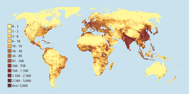
Population Density Map
This map shows where people have settled around the world and their approximate number. As you can clearly see from this map, water access appears as a major deciding factor determining where people settle.

Caitlin Pibus
---
"Picture of the Week: World Population Density ." Ponder This Blog... . http://www.ponderthis.net/2007/07/19/picture-of-the-week-world-population-density/ (accessed November 8, 2010).
Caitlin Pibus
08/11/10
---
"Picture of the Week: World Population Density ." Ponder This Blog... . http://www.ponderthis.net/2007/07/19/picture-of-the-week-world-population-density/ (accessed November 8, 2010).
Settlement Around Water
From the first major formation of civilizations, water has always been a central body around which civilization gathers. Before methods of transporting water were developed, the physical locations of bodies of water were the basic motivators of determining where civilizations would develop. The importance of water to safeguard an abundant and stable food supply, due to favourable conditions for hunting, fishing and gathering resources provided an initial wide spectrum economy that triggered the creation of permanent villages. Such as Mesopatamia, which is often cited as “the cradle of civilization”. Its location was centered around the convergence of the Tigris and Euphrates Rivers, which produced rich fertile soil and a supply of water for irrigation. The civilizations that emerged around these rivers are among the earliest known attempts humanity made at establishing non-nomadic agrarian societies. The fact that this location also lead to the emerging of other strong civilizations, such as Ubaid, Sumer,Akkad, Assyria, and Babylon is also strong support for the theory that Mesopotamia is the cradle of civilizations. These concentrated developments around water also affect the societies themselves and how they function. A clear example of this is settlement around the Nile around 2500 BC. From around 7000 BC to 3000 BC the climate of the Sahara had been much moister, offering good grazing land even in areas that are now very arid. However natural climate change after 3000 BC led to progressive arification of the region. It has been suggested that as a result of these changes, around 2500 BC early tribes from the Sahara were forced to concentrate along the Nile river where they developed a settled agricultural economy and more centralized society. Another example of water settlement influencing the society itself is demonstrated through the cities of Italy during the Renaissance. The cities of Italy prospered during the late Middle Ages, serving as trading posts connecting Europe to the Byzantine Empire and the Moslem world via the Mediterranean Sea. Commerce enriched and empowered regions in which the feudal system had not taken a strong hold, especially in northern Italy. The atmosphere that was developed through this water development turned out to be what even lead to the Enlightment, a pivotal development that has shaped our world today.

08/11/2010
---
"Cradle of Civilization." Wikipedia. en.wikipedia.org/wiki/Cradle_of_civilization (accessed November 8, 2010).
Eder, James M., and Seth A. Roberts. Barron's AP European history . 4th ed. Hauppauge, N.Y.: Barron's Educational Series, 2008.
Eder, James M., and Seth A. Roberts. Barron's AP European history . 4th ed. Hauppauge, N.Y.: Barron's Educational Series, 2008.
China's Grand Canal


From the Tang to Qing dynasties, the Grand Canal served as the main artery between northern and southern China and was essential for the transport of grain to Beijing. Although it was mainly used for shipping grain, it also transported other commodities and the corridor along the canal developed into an important economic belt. Records show that, at its height, every year more than 8,000 boats transported 4 to 6 million 240,000–360,000 metric tons of grain. The convenience of transport also enabled rulers to lead inspection tours to southern China.
Since the founding of the People's Republic of China in 1949, the canal has been used primarily to transport vast amounts of bulk goods such as bricks, gravel, sand, diesel and coal. The Jianbi ship locks on the Yangtze are currently handling some 75,000,000 tons each year, and the Li Canal is forecast to reach 100,000,000 tons in the next few years.
Jamie Banks- 08/11/2010
---
"Grand Canal (China)." Wikipedia, the Free Encyclopedia. Web. 02 Nov. 2010. http://en.wikipedia.org/wiki/Grand_Canal_of_China.
Israel's Water Project
To bring in more water, and create much needed energy through hydroelectricity, Isreal in a joint venture with other countries may embark on a two billion dollar project pumping water from the mediteranian or red seas to the dead sea.
An alternative to stand-alone plants for desalination in the near future lies with the renewed interest in Med–Dead or Red–Dead proposals to bring seawater from either the Mediterranean Sea or the Red Sea and convey it by means of tunnel and canal to the Dead Sea (see Figure 1 on p. 6). Because of the 400-m difference in elevation, the projects were originally conceived as a means of generating electricity (and replacing water in the rapidly diminishing Dead Sea basin). Although part of the electricity generated would be required to pump water across the Judean Hills (in the case of Med–Dead) or along the Jordanian border (in the case of Red–Dead), the plans alleged that enough would remain to power a substantial agroindustrial complex and thus make the projects viable. Plans for the Med–Dead Canal have now been reconceived so
that all of the electricity generated would be devoted to desalination, thus reducing by about two-thirds the external energy requirements (Gur 1985). Viability would be enhanced by the supply of fresh water to potential agricultural land and industrial plants. The estimated cost of this project is $2 billion, with a series of hydroelectric stations (costing $340 million each) generating electricity and producing desalinated water at half the current cost (Moore 1993). The Italian government has expressed interest in participating in the project.
Although recent discussion has focused on the Red–Dead Canal (Kally 1993), each of the two routings has advantages and disadvantages. The Red–Dead Canal would be twice as long and have to climb twice as high before beginning its descent, but would avoid populated areas and the need to tunnel through the Mountain Aquifer. Although the Med–Dead route has a perceived advantage for some, because it could be built largely or entirely within Israel, others find the Red–Dead Canal appealing because it would have to be binational and, therefore, could solidify a peace treaty with Jordan. As a practical matter, either project probably requires agreement among Israelis, Palestinians, and Jordanians because the Jordan River and the Dead Sea are shared international waters. Jordan has clearly indicated its preference for the Red–Dead option (Mideast Mirror, 31 March 1994, p. 12). Israeli Foreign Minister Shimon Peres also seems to favour the Red–Dead option (Mideast Mirror, 29 June 1994). Both nations see it as a key to developing their southern frontier regions from the Red Sea along the Arava Valley to the Dead Sea.
Currently, a variation on the Med–Dead Canal, known as the “Gur Plan,” has been attracting the most attention. According to this plan, fresh water from springs feeding the Upper Jordan River would be diverted to recharge the Coastal Aquifer to restore its original level and quality. This water would be replaced by desalinated water, which would be pumped back up to Lake Kinneret and would have the added benefit of improving water quality in the Lower Jordan (which is now too saline even for most agricultural uses).
Energy:
The big problem even in the middle east rich in energy resources (generally) is the huge amount of energy it takes to obtain water. In poor countries such as Jordan, this brings the cost of water to an almost intolerable price for the people of the slums.
Energy is required to make use of all but the most local surface and shallow underground water. Most importantly, today energy is used for pumping water, both vertically from underground sources and horizontally from place to place. Farms tend to be located in valleys, which limits pumping costs, but this is not true of cities. For centuries, based on military, cultural, and environmental considerations, cities have historically been placed on hills or mountains, which increases pumping costs. Furthermore, wastewater must be removed (in this case, the elevation of cities is a minor advantage) and treated, both of which require energy. Wastewater treatment can refund some of that energy through the recovery of methane, but in most cases only enough is captured to operate the treatment plant itself. If water must be treated further before it can be used, still more energy will be required. As indicated in the foregoing, if desalination is contemplated, energy and capital costs become the dominant variables.
Currently, Israel uses 12% of its electricity just to pump water (Schwarz 1992). In Jordan, the proportion is almost 20%. The proportion of electricity used in Israel to pump water used to be 20% but has declined as a result of increases in total electricity use. Most of this electricity is used to pump water up from Lake Kinneret, which lies 209 m below sea level, to the National Water Carrier, which operates at and above sea level. Detailed figures are not available, but estimates suggest that as much as one-third of urban electricity use is for water treatment and pumping. In contrast to the Israeli population, which is concentrated along the coast, the Palestinian population is, with the exception of Jericho, concentrated in the highlands, which increases net pumping costs. In Israel today, it takes 1 kWh (3.6 MJ) to deliver one litre of water.
Water Info Comparisions:

(Israel, Central Bureau of Statistics (1992) and WRI (1992). GDP, gross domestic product.)
---
Year, By The. "Chapter 3. Water Supply and Demand: International Development Research Centre." INTERNATIONAL DEVELOPMENT RESEARCH CENTRE | CENTRE DE RECHERCHES POUR LE DÉVELOPPEMENT INTERNATIONAL. Web. 02 Nov. 2010. http://www.idrc.ca/en/ev-29775-201-1-DO_TOPIC.html.
Jamie Banks- 08/11/2010
Water Availability and Uses
Statistics:
-884 million people lack access to safe water supplies; approximately one in eight people.
-A bathtub holds 151 litres of water, the average person in the slums gets about 30 litres for all of their daily needs
-3.575 million people die each year from water-related disease.
-The water and sanitation crisis claims more lives through disease than any war claims through guns.
-Poor people living in the slums often pay 5-10 times more per liter of water than wealthy people living in the same city.
-An American taking a five-minute shower uses more water than a typical person in a developing country slum uses in a whole day.
-Ancient romans had better water quality then 50% of the world today
-70% of the worlds fresh water supply is devoted to agriculture
-Only 63% of the world have access to at least minimal sanitation
The above gives an idea of the gravity of the water situation, how many people are effected and how severe the problems are.
Maps:
Map showing water use in each country.

(World Resources; Water)
Map showing the type of water available in each geographic region.

(Climate.org; Water)


(Maps of the World; World Freshwater)
This next map shows population density, compared with the maps above, one can see that wealty countries have the highest density near fresh water, and the poorest countries are the densest countries lacking water.

(MIT; glabal change)
Jamie Banks- 08/11/2010
---
"Fresh Water Mapped | Spatial Sustain." V1 Magazine - Promoting Spatial Design for a
Sustainable Tomorrow. Web. 02 Nov. 2010.
http://vector1media.com/spatialsustain/fresh-water-mapped.html.
Sustainable Tomorrow. Web. 02 Nov. 2010.
http://vector1media.com/spatialsustain/fresh-water-mapped.html.
"MIT Global Change Joint Program Report 18." MIT. Web. 02 Nov. 2010.
<http://web.mit.edu/globalchange/www/rpt18.html>.
<http://web.mit.edu/globalchange/www/rpt18.html>.
"Water and Climate Change." Climate Institute. Web. 02 Nov. 2010.
<http://www.climate.org/topics/water.html>.
<http://www.climate.org/topics/water.html>.
"Water.org » Water Facts." Water.org. Web. 02 Nov. 2010. <http://water.org/learn-about-the-
water-crisis/facts/>.
water-crisis/facts/>.
"World Freshwater Resources." World Map, Map of the World. Web. 02 Nov. 2010.
http://www.mapsofworld.com/world-freshwater-resources.htm.
http://www.mapsofworld.com/world-freshwater-resources.htm.
(http://water.org/learn-about-the-water-crisis/facts/)
Water and Urbanism
Some statistics :
2,5 % of the water on Earth is fresh water
10 % of that 2,5 % is accessible for human use
8 % of the 10 % is consumed, 22 % is used industrial processes and 70 % is used in agriculture
2,5 % of the water on Earth is fresh water
10 % of that 2,5 % is accessible for human use
8 % of the 10 % is consumed, 22 % is used industrial processes and 70 % is used in agriculture
There is however a global inequality in the availability of fresh water. In other words, some counties have more water than others. According National Geographic’s Daily News:
In sub-Saharan Africa, existing water storage is equal to less than 26,400 gallons (100 cubic meters) per person, compared to 1.3 million gallons (5,000 cubic meters)—enough to fill two Olympic-size swimming pools—in the U.S.
(How do you Stem a Global Food Crisis? Store More Water)
Water availability is not only a crisis for potable drinking water but for the corps and agriculture as well. 94 % of corps in the Sub-Saharan desert relies solely on rain water.

Areial images showing a decrease in vegetation during a 2003 drought in southwest Africa.

Image created fir the Aigües de Barcelona in response to a 2008 drought in Barcelona
"Water « essential urbanism." essential urbanism. http://essentialurbanism.wordpress.com/tag/water/ (accessed December 10, 2010).
Louis-Pierre Bélec - 07/11/2010
Subscribe to:
Posts (Atom)